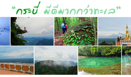
If you go to Krabi and don't go to the sea, where else can you go?

This time, we will take you to the south to see the natural beauty of Krabi province. When it comes to Krabi, most people think of the sea. But did you know that "Krabi has more to offer than just the sea"? If you go to Krabi and don't go to the sea, where else can you go? We have collected some pictures of areas that are easy to get to for you to see. Follow us.
Location
- Long-wattled Umbrellabird
- Tiger Cave Temple
- Emerald Pool
- Hot tears
- Black Crab Square
- Walking Street
Follow our next travel adventures at:
GowithAmp
https://facebook.com/GowithAmp
"Book a 0 Baht flight promotion and leave it for a long time."
Late last year, Thai AirAsia launched a Big Seat promotion for 0 baht flights during the green season, or rainy season. We were primarily interested in domestic routes, particularly Krabi. During this time, there were fewer tourists and lower prices. However, the promotion was only available on weekdays, so we booked it in advance. Earlier this year, we received emails and SMS notifications informing us of a "retime" for both the outbound and return flights. The travel dates could be changed (free of charge) 14 days before and after the original travel date (counting the first day of the original travel date as day 1). We therefore postponed our trip to coincide with the weekend.
Conditions for Free Flight Reschedule in Case of Airline's Notice of Flight Date or Time Change
- Less than 45 minutes: Not eligible for postponement.
- 45 – 119 minutes: Reschedule within the same day.
- 120 – 179 minutes: +/- 7 days shift from the original date.
- 180 minutes or more: Reschedule +/-14 days from the original date.
As the departure date approached, I felt hesitant about traveling alone. Coincidentally, AirAsia Big was running a promotion where I could redeem points for flights. I decided to forgo my original 0 baht ticket and reclaim the airport tax later (200 baht roundtrip) in exchange for a new flight priced at 770.80 baht for two people (including taxes and fees). This allowed me to have a travel companion and share expenses. For this trip, I opted for a relaxed and spontaneous approach, prioritizing affordability over meticulous planning. (This trip was not initially intended for documentation or review, so some moments may lack visual representation, such as photos of the accommodation.)
Day 1: Khao Hin Ngorn - Stay in the City
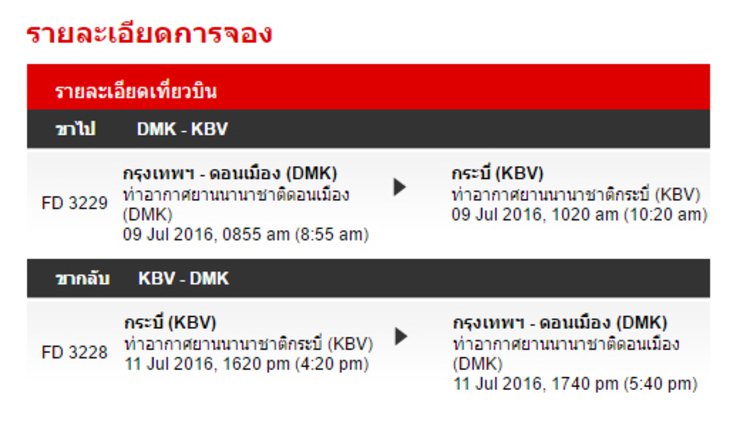
Flight 8.55 a.m. arrives at Krabi International Airport at 10.20 a.m.

To reach the city center, I took a shared taxi (songthaew) which required me to walk outside the airport and cross the street to wait on the opposite side. There were many songthaews available, and I could ask the driver which one would take me to my desired destination. Most of them pass through Lan Po Daeng or terminate at the Vogue Department Store in Krabi. The fare was 20 baht per person.
We disembarked in the middle of the market before reaching the Vogue Department Store in Krabi and walked to the motorbike rental shop. My fellow travelers had rented from this shop frequently, so it was convenient. I had someone to show me around! Yay! I rented one bike for 250 baht per day (1 day is 24 hours; our trip was booked for 48 hours). After receiving the helmets and rental documents, we went to the accommodation to check in and change clothes.
Boss & Benz House
Budget-Friendly Accommodation with a 25% Discount
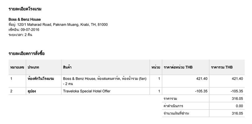
This accommodation was booked through an application, offering an additional 25% discount. For two nights, the total cost was only 316.05 baht. The room is a fan room with a shared bathroom, but the bathroom is surprisingly clean and looks much better than expected. Most of the guests are foreigners, backpackers, or budget-conscious travelers. It is highly recommended. (*Prices may vary depending on the day of the week, time, and promotions.)
Address: 120/1 Maharat Road, Soi 22, Pak Nam Subdistrict, Mueang District
Contact number: 083-691-3933
Additional: https://www.facebook.com/Boss-Benz-House-289973277717774/

“Where should we go first?” asked one of the trip participants. We had already discussed our destinations roughly, but we hadn't planned the details. Without hesitation, I suggested we head straight to the main purpose of our trip: "Khao Hong Nok." We quickly dropped off our belongings, changed into comfortable clothes, and set off on our adventure!

Wait, I'm hungry. I forgot I need to find something to eat first.

Long-wattled Umbrellabird
The Hornbill Mountain is located within the Hat Noppharat Thara-Mu Ko Phi Phi National Park. The park headquarters here is a sub-unit, simply called Hat Thap Kaek Park. It is one of the 28 "He Told Me" locations, a project to stimulate tourism under the concept of "creating stories from beliefs to attract tourists to various destinations, creating a trend for Thai people to travel within the country, and encouraging people to travel at least once in their lifetime."
"In this dreamland for travelers, surrounded by one of the most beautiful panoramic views in Thailand, who would have known that this land is the end of a love story of a naga, causing it to shed tears, forming a small pond with clear water flowing all year round. Locals believe that if you make a wish and rub your face with the water, your wish will come true and bring good luck to your life."
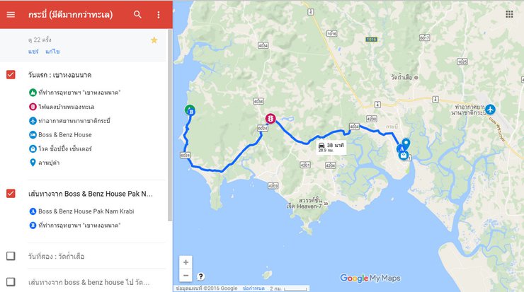
Directions: It is said that "go to Ban Nong Thale via route 4034 for about 15 kilometers, you will reach Ban Nong Thale. Notice the Ban Nong Thale School on the right-hand side. When you reach the Ban Nong Thale traffic light, turn left onto route 6024. There will be a signpost for Klong Muang Beach." This route has many famous hotels. "Until you reach the Amari Vogue Krabi Hotel on the left-hand side, go up the hill for another 500 meters." You will reach the park office. The total distance is about 30 kilometers.
Contact officer: 086-143-6144
Porter or guide: 1,000 baht/person/trip

Khao Ngon Nak is a stunning viewpoint offering breathtaking sunrises and sunsets. It boasts panoramic views of Ao Nang, Koh Hong, Talay Waek, Koh Yao, and Ao Thalane. Established as a tourist destination in 2012, the peak stands at 500 meters above sea level. The hiking trail spans 3.7 kilometers, which may seem manageable, but the ascent takes approximately 2-4 hours depending on individual pace.
Upon arrival at the park headquarters, visitors are required to sign in and out. Contact information for park officials is available for emergencies or delays. Mobile phone reception is available, although it may be intermittent.
At this point, our travel companions left us in the middle of the road. Haha! The reason given was that they had already been here once and couldn't face the arduous journey again. So, we agreed to part ways. Suddenly, we spotted a group of four women who seemed to be around our age. After signing in, it was time to make some new friends.
Before embarking on the journey, the staff will explain the route on the map, the time, and other important information.

Take a picture at the sign before going up.
On the left side, there was also a small waterfall (but I didn't capture it in a picture).

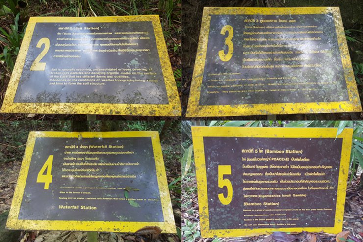
The 3.7-kilometer nature study trail consists of 13 stations, each with a sign providing information about the characteristics of each section of the forest on either side of the path. (Why did I only find signs for station 12? Where is station 13? If anyone knows, please let me know.) I would like to whisper that "the path between stations 8 and 9 is the longest and most challenging, requiring a climb similar to a small hill, which is the most thrilling part. My heart was racing. This is the part that made me tired."

Let's start with some lighthearted fun, taking turns snapping photos here and there.

As we walked, we chatted intermittently. I learned that the older woman was a pharmacist from Krabi. The other three, who were younger than me, were pharmacy interns. Some were from Krabi, while others came from the north but were interning in Krabi. Everyone was friendly and welcoming. I felt truly fortunate.

This area boasts lush forests, and the current rainy season has made the entire trail verdant. However, let's hope the rain holds off for now. The path is well-defined, so there's no chance of getting lost.


The initial section of the path appears to have been intermittently lined with construction materials. These materials may have been intended as seating, although this remains unconfirmed as inquiries with officials were neglected.

Not only are the trees and grass lush and green, but there are also many small and large mushrooms growing along the path. For example, in this picture, there is a cute little orange mushroom.

And we have arrived at the sign for Base 8. What kind of cruelty is this? Please read on to find out.

The initial phase was still comfortable, with an atmosphere that inspired awe and wonder at the beauty of nature.

As we continued our trek, one of our fellow travelers began to feel dizzy and nauseous. We stopped several times to rest and wait, and I secretly considered continuing the ascent alone, reasoning that they would be fine with their companions. (Clearly, I wasn't concerned about myself at all.) However, since we had started the journey together, we decided to press on. After walking for some time, our companion's symptoms worsened. The pharmacist suggested that we proceed with one of the group members while the others followed later. I locked eyes with the companion who would accompany me, and I could sense a surge of determination through their gaze. (Okay, maybe I'm exaggerating a bit.) We agreed to the plan, and my companion and I set off towards our destination.
We encountered a large log and took a short break. Along the way, some people overtook us, while others walked down the opposite direction. Usually, we would hear words of encouragement from those coming down, such as "Just a little further, you're almost there." But this time, it was quite the opposite. "It's still quite a distance away." "It's going to be a while." "The path ahead is difficult to climb, you'll need to climb and hold onto branches to get up." ...... Well, they seemed very sincere and honest. ^^"

We reached a point where we had to look at each other's eyes. It was a very steep climb, and we had to lift our legs high and grab branches to support ourselves, just as people had told us. They were not lying at all.

Initially, we thought the climb would be a breeze, but it turned out to be quite strenuous, leaving us drenched in sweat. We continued walking and came across a resting spot, but we decided to keep going as we felt the engine was still working and didn't want to stop. (The trail was tough, but we were even tougher!)
Let me introduce you to our companion, "น้องนะ". She is from Krabi and is a Muslim. She has a determined look in her eyes and seems sincere. N้องนะ is very small, probably around 150 cm tall compared to me, but she is strong! Don't let her small stature fool you, she is very tough! ^^

The trail alternates between easy and challenging sections.


The first viewpoint we stopped at is on the right-hand side.

Another captivating charm of trekking is the vibrant and eye-catching wildflowers.

A short walk will lead you to another scenic viewpoint on the left-hand side.

1.5 kilometers to the sign.

Approaching the 11th base, the truth is getting closer.

At this point, there was a fork in the path leading to the waterfall on the right. However, due to time constraints, we did not visit the waterfall.

A massive boulder, impossible to miss and unforgettable to all who encounter it.

We have reached the 12th base. It is located right next to a resting area, so we decided to take a short break. We were really tired at that time.


The path is lined with moss, and there is even a miniature waterfall! Yes, you read that correctly: a "miniature waterfall." This is an area where water flows over small, cascading rocks, resembling a waterfall but on a much smaller scale.

We are almost there. Let's stop here again for a moment to enjoy the fresh air and the beautiful view. We can take turns taking photos and selfies. Oh, this is so much fun!


The group that was following behind also sent messages to ask the younger sibling periodically. They were in a hurry to catch up, having enjoyed the view and taken photos to their heart's content. They then continued on their journey. If you wear tight pants, you won't be able to step up like this. Or you'll probably end up with a torn crotch. Haha.


After a short walk, we came across this sign! It took us almost 4 hours in total.
(This is because frequent breaks in the early stages resulted in a longer duration.)

Here, we also discovered another heart... moss growing on a rock in the shape of a heart. Nature truly creates beauty beyond expectations.

Reaching the summit, my phone battery was critically low, so I decided to conserve it for emergencies. (I had neglected to bring a power bank.) Fortunately, I was not alone, which offered some reassurance. Around 7-8 foreigners were present, some departing and others lingering to capture photos at the popular viewpoint. We opted to wait, admiring the surrounding flora. Looking down, I noticed tiny, pinwheel-shaped blades of grass, unlike anything I had ever seen before. They were quite charming.

The plant has pink flowers and a bushy stem that grows approximately 50 meters tall. The flowers are distributed throughout the plant.

Come sit with me on the other side of the rock.

The view was breathtaking, stretching as far as the eye could see. However, the slowly drifting mist obscured the scene, leaving it hazy and indistinct.

Seizing the opportunity when the popular spot was empty, we took our chance to join the others.


This is a popular spot called "Naga Crest" where everyone wants to come and pose for photos. Finally, we've arrived! I'm so happy! The view is amazing, and the air is so fresh! I wish I could stay here overnight (not because I'm tired, haha!).

A photo of the photographer, taken at the Naak headland, where the atmosphere is just as good.

Gazing once more at the view before me, even though the mist faintly shrouded it, I could still make out the vast panorama.


Shortly after, we heard a sound! Oh wow! The rest of the group had caught up, walking very fast. Haha! We then took turns taking photos to our heart's content. A little while later, fog started to roll in from nowhere, turning everything white. We could barely see the view anymore, but we continued taking photos.


We tried to find the Naga's eye spring, but we couldn't find it. We didn't know where it was. We walked in alone for about a hundred meters and then walked back out because it was getting close to dusk. If we kept wandering, we would definitely have to go back down in the dark. I thought to myself again that it was getting close to dusk and I should go down, but then I thought that we came together and we should go back together. So I decided to wait.
We sat and waited, taking pictures of the scenery and each other. We breathed in the fresh air, savoring its purity and wishing we could bottle it up and take it home.


A clear comparison between light fog and heavy fog.

As the afternoon wore on, it approached five o'clock. The fog began to thicken, and the air grew cool. After our group had taken their fill of photographs, we decided to head back. Before leaving, I captured one last image of the miniature trees.

Everyone was eager to descend the mountain, and the return trip was much faster due to the downhill slope and the need to reach the bottom before nightfall. The path remained challenging at times, as expected. Checking my phone, I saw messages from fellow trekkers inquiring about our progress. I quickly replied that we were on our way down, and that no one was interested in taking pictures anymore. We were practically running, enjoying the thrill of the descent.

Walking in the forest feels like dusk arrives earlier than usual due to the dense tree cover that blocks most sunlight. The sounds of birds, cicadas, crickets, and various animals create a unique atmosphere (which could be eerie if walking alone). Halfway down the trail, my friend and I were still practically running or leaping ahead, full of energy. We stopped intermittently to wait for the others. As the sound of a waterfall grew closer, we knew we were nearing our destination. Our excitement grew, and we picked up the pace again. Suddenly, we saw someone standing in front of us! It turned out to be one of our fellow hikers who had come to find us because it was getting dark and they couldn't reach us.
At this point, we have waited for everyone to arrive. Therefore, we would like to express our gratitude to all participants. We must now bid farewell. It was a pleasure meeting you all and sharing this challenging and exciting journey together. Thank you. Goodbye.... ^____^
We quickly walked back down with our fellow travelers. When we reached the entrance, we signed out. I really wanted to jump into the waterfall; it would have been so refreshing. But it was getting late, and we needed to use the restroom and wash up before heading back to the city. We were soaked in sweat, as if we had taken a shower while still wearing our clothes. But we were so happy and satisfied. We loved the atmosphere, the feeling of the forest, and the path we walked. We want to go hiking every week! By the time we reached the city, we were starving. We decided to eat at this restaurant, which I highly recommend. Every dish costs 50 baht, whether you order a regular or a large portion. Isn't that great?

Not only that, but if you buy rice here, you also have the right to refill soup for free, with two options: clear soup and spicy soup. I must say, it's more than worth it. The soup is full of vegetables and meaty chicken ribs. The taste is delicious and satisfying. You can eat as much as you want! (Advertising style description) Oh! There's also plain rice for 10 baht per plate.
This restaurant is located opposite the Vogue Department Store in Krabi, slightly up towards the traffic light intersection. If you're visiting Krabi, don't forget to try this restaurant. Highly recommended!

After a satisfying dinner, we decided to indulge in some roti across the street. The roti shop is located on the same side as the Vogue shopping mall. As the night wore on, the crowd grew, drawn by the shop's well-deserved reputation for delicious roti. Each table was offered a complimentary pot of fragrant hot tea, adding to the delightful experience.

After returning to our accommodation and taking a shower, we thought we would be exhausted and fall asleep quickly. However, we did not feel tired at all. We were surprised by our own resilience and stamina.
Day Two: Tiger Cave Temple – Walking Street – Stay in the City
The original plan was to visit Wat Tham Suea in the morning and watch the sunset at Nong Thale in the evening. However, the sky was overcast since the morning, so we started our journey late. We stopped to refuel the car for 50 baht. Before we finished refueling, it started to rain heavily. At that moment, all we could do was wait. We waited until the rain stopped and then went to find something to eat because we hadn't eaten anything since morning. We decided to have a combined meal. We found a som tam restaurant next to the 7-Eleven near the gas station. The prices here are reasonable, the taste is acceptable, and there are many menus to choose from. For this meal, we spent 210 baht. Even in Krabi, we still can't escape Isaan food. Haha.

Our bellies full and the rain having conveniently stopped, it was time to journey to the
"Tiger Cave Temple".
Temple History: "In 1975, Luang Pho Chamnien wished to find a new place to practice Dhamma. He had a vision in his mind that it was a place with mountains.
Surrounded by caves, including the "Tiger Cave" and many other caves, it is also located in Krabi Province. As soon as the vision appeared, he felt a sense of love for the place, as if he had been familiar with it before. Luang Pho asked Phra Ajarn D to search for a place to establish a monastery. Eventually, Phra Ajarn D found several places, including Tiger Cave. Luang Pho had the opportunity to visit the cave as suggested by Phra Ajarn D, and it was exactly the same as the vision he had seen. Luang Pho Nien led a group of monks...
53 novice monks and 56 nuns from Wat Sukonthawas arrived at this place called Tiger Cave, or in the past, the temple was called "Samnak Song Tham Na Ching", after the name of the village, on March 25, 1975. It was changed to "Wat Tham Sua" on August 2, 1990. They have been pioneering the opening of this place as a Vipassana meditation practice site until the present day. The name Wat Tham Sua comes from the fact that in the past, there were many tigers living in the area of the cave located in front of Khao Kaeo. Inside the cave, there are also natural stones in the shape of tiger paws. The general condition of Wat Tham Sua is a forest park with caves, rock shelters, and natural cave sources such as the Kinnari Cave, Lod Cave, Chang Kaeo Cave, Look Too Cave, Snake Cave, Turtle Cave, and Tiger Paw Cave. The most prominent and popular feature of Wat Tham Sua seems to be the ".
(Source: https://en.wikipedia.org/wiki/Tham_Sua_Caves)

Directions: Follow Google Maps for a distance of approximately 9 kilometers from your accommodation. Take Maha Rat and Chuthamat roads to Highway 411. Turn right onto Phetkasem Road (Highway 4) and continue until you reach the Tham Sua intersection on the left. Turn left onto Highway 1067 and follow the road. There will be signs indicating the way to the temple on the left-hand side. Keep an eye on the left side of the road, as the temple will be located there. Once you reach the "M.1 Ban Na Ching Public Service Unit," the temple will be visible. Turn left and you will arrive shortly.

It took us about an hour to reach the temple. Upon arrival, we were offered sarongs to cover our legs, as shorts, short skirts, and tight pants were not permitted. The sarongs were available for a 20 baht donation and came in a beautiful blue color. (Please remember to return the sarong after your visit.)

We previously visited this temple four years ago, but at that time we only walked up to the cave. This time, we will climb to the highest point of the temple, which is about 600 meters above sea level, to enjoy the view.

Before ascending the 1,237 steps, we stopped by the temple shop to purchase a bottle of water each. We braced ourselves physically and mentally for the climb. (Interestingly, the actual number of steps seemed to exceed the number indicated on the sign.)

The previous climb up Khao Hngon Nak was brutal, but this one was a different kind of challenge. The steep, wide steps required frequent breaks, and while some people sprinted up the stairs, others walked briskly. We opted for a more mindful approach, chanting "Bud-dho" with each step: left foot, inhale "Bud," right foot, exhale "dho." This helped regulate our breathing, preventing exhaustion and excessive heart rate. Despite the effort, we were drenched in sweat by the end of the climb.

The ground is teeming with inchworms, their long bodies wriggling and squirming. They are quite adorable, with their fuzzy fur and delicate movements.

Along the walkway, there are rest stops at regular intervals. Please do not stop on the stairs. Please step aside to allow those who are following you to walk up conveniently.

After climbing up to the resting area, just before reaching the top platform, I was able to enjoy the view and rest for a short while before the rain started again. The sky turned gray, and the fog covered everything, making it impossible to see the view.


This location offers free Wi-Fi.

The sky is overcast, shrouded in clouds. It appears gloomy, but it doesn't evoke a sense of loneliness.

After the rain stopped, I walked up to the top.

Looking down below, you will find a view of the city and the unfinished pagoda.

This passage describes a location featuring:
- "Phra That Chedi Yot Khao Kaeo": This likely refers to a revered Buddhist stupa situated atop Khao Kaeo hill.
- A large Buddha statue: This suggests the presence of an imposing Buddha sculpture, likely holding significant religious importance.
- A replica of the Buddha's footprint: This indicates the existence of a replica of the sacred footprint of Buddha, potentially serving as a pilgrimage site.


Art at the base of the Buddha statue


From this vantage point, one can enjoy panoramic views of both the cityscape and the surrounding mountains.


The mountain occasionally offers stunning views of a sea of mist. Although we only saw a small amount during our visit, we were fortunate enough to witness the mist and clouds hovering near the mountains.

The atmosphere is consistently captivating, with stunning views, pleasant weather, and an overall delightful ambiance.


Art and nature, a harmonious landscape.


The breathtaking view from here makes it hard to leave. I'd love to stay and watch the sunset, but we've heard that the rain has made the road to Nong Talay muddy and difficult to navigate. Additionally, the cloudy skies suggest that even if we make it there, we might not be able to enjoy a beautiful sunset.

"Look at me with both your eyes and your heart, not just one or the other. An unappealing exterior conceals a greater beauty: the soul."

After enjoying the view for a while, we decided to head back down. The descent was so steep that I almost wanted to roll down instead of walking! Haha! My legs were already tired from the climb, and the descent made my knees ache even more. This was because we had to bend our knees to step down. Some people suggested that it would be faster to descend backwards... It's up to you, really. The stairs were quite far apart in some sections, which made me feel a little sorry for my knees. ^^" We still had plenty of time left after returning to the city, so we took a walk around the Black Crab Square and admired the view of the mountains flanking the water.

Today, I went for a walk at the walking street. I was planning to find something to eat there, but the prices were quite expensive, so I just walked around and looked.
Available every Friday-Sunday from approximately 5:00 PM to 10:00 PM. The location is on Maharat Road, Soi 8 (near the Vogue Department Store).

The next day, I went back to the same rice shop I had eaten at the day before. Where else can you find such good value? Every dish is 50 baht, both regular and special. The soup is also free, both plain and tom yum. The shop opens at five in the morning (in southern Thai, this means 5 pm, haha!). The highlight is the voice of the shopkeeper, who constantly invites customers in both Thai and English in a loud and serious voice, typical of southern people.

After a satisfying meal, they continued to a roti shop, drawn back by the delicious tea.

Day Three: Emerald Pool – Klong Thom Hot Springs
As morning arrived, the rain began to fall. I felt a little regret, then went back to sleep. Haha! But soon the rain stopped. It was time to wake up, take a shower, put on clothes, and head out with a fresh face early in the morning to "Emerald Pool," located in the Khao Pra-Bang Kram Wildlife Sanctuary, Khlong Thom District, Krabi Province.

According to Google Maps, the distance is approximately 60 kilometers, which would take about 1.5 hours. This is a relatively long distance for a motorcycle journey.
Today, we took Uthakit Road (Highway 411) along the Pak Nam Krabi Canal, which leads to Phetkasem Road (Highway 4). We drove straight for about 40 kilometers until we reached the intersection before the Khlong Thom Tai Subdistrict Municipality office. Look to your left. Before the alley, you will see "Phongsongdee Gold Shop 5." Next to it is a 7-Eleven at the mouth of the alley. Turn left here and drive for another 17 kilometers. You will reach Emerald with signs along the way. You can also take other routes, but we chose to follow Google Maps, which seemed to be the shortest route. (The Google Maps route may not be the best option, as it sometimes takes you on dangerous roads. Therefore, it is advisable to research the route before your actual trip.)

Upon arriving at the entrance to Emerald Pool, find a parking spot and walk inside. There are several shops and restaurants in this area, but we must have arrived too early, as none of them were open yet. Only one water vendor was setting up her cooler, so we bought a bottle of water each and continued walking until we reached the checkpoint of the wildlife sanctuary at the entrance of the nature trail leading to Emerald Pool.
Access Hours: 8:30 AM - 5:00 PM Daily
The entrance fee is as follows:
Thai adults 20 baht, children 10 baht.
Foreigners: Adults 200 baht, Children 100 baht.
After paying the entrance fee and receiving a coupon, visitors can choose between two walking paths. The first path is a nature trail with a wooden bridge that extends into the forest, covering a distance of approximately 1.4 kilometers. The second path is a gravel road, approximately 800 meters long. Both paths have signs with information about the different trees. We opted for the shorter path, the gravel road.
Walk in until you see this sign. Walk a little further and you will arrive.

The water flowing through the walkway is stunningly beautiful!


The Emerald Pool is approximately 20 x 25 meters in size and 1.5 meters deep. The water temperature ranges from 30-50 degrees Celsius, originating from the magma beneath the pool's bottom layer, which releases heat.


When we arrived, there was no one else around. Most tour groups typically arrive around 10 am. Only staff members were present, checking the cleanliness of the pool.

The water is crystal clear, allowing you to see small fish swimming playfully in the pond.

To preserve the natural environment, please refrain from using soap, shampoo, detergent, or any chemical substances in this area. These substances can harm the diverse aquatic life that resides in this water.


The water in Emerald Pool flows from a natural spring or "Bo Phut" spring. Visitors can walk approximately 2 kilometers further into the forest, where a wooden bridge built by park rangers allows access. However, during our visit, the path to the spring was temporarily closed between May and October (we missed the opportunity to see the beauty of the spring). The spring water is naturally filtered through limestone, making it rich in calcium carbonate. This is evident in the water flow into the pool and the limestone deposits on the rocks within Emerald Pool. Additionally, the alkaline nature of the water causes minerals and other substances to precipitate, including algae and bacteria that thrive in such conditions. This results in the clear water's characteristic blue or green color.


We spent about an hour here before continuing our journey, even though we didn't want to leave yet. We had to make good time.

We continued our journey to the "Saphan Yung Hot Spring".
To return, follow the same route you took to get here. After approximately 8 kilometers, you will see a sign on your left indicating the entrance to the hot spring. Continue for another 2 kilometers to reach the entrance to the hot spring.
Entrance fee
Thai adults 20 baht, children 10 baht.
Foreigners: Adults 200 baht, Children 100 baht
Due to heavy rain the night before our visit, the waterfall turned reddish (water mixed with soil) and the water temperature was not warm. Therefore, the officials closed the waterfall but allowed visitors to enter without paying the entrance fee. This was exactly as the officials had informed us before we entered. The water was so red and cloudy that it was not inviting to swim or soak in. We stood there with regret, only dipping our hands and feet into the water that had lost its warmth and clarity.

The Namtok Ron Khlong Thom, also known as Namtok Ron Saphan Yung, is a hot spring waterfall fed by a natural spring in the forest. The water temperature is slightly higher than typical waterfalls, ranging from 40 to 50 degrees Celsius. The waterfall is small, approximately 3 meters high, with cascading rock pools resembling small bathtubs, 0.5 to 1 meter deep. Visitors can enjoy soaking in the warm water.


Shortly after setting out, the rain started again, initially just a light drizzle. However, it soon intensified, forcing me to seek shelter at a roadside pavilion. After waiting for the rain to subside, I continued my journey, arriving back in the city at noon. I returned the rental car and walked back to my accommodation. After showering, I walked to P'Dam Thara's restaurant, where I had lunch before heading back. The walk was about 2 kilometers, but I was determined, as I was very hungry!

Brother Dam's Shop
Located in Thara Park, this restaurant offers both seafood and general dishes. The local specialty, a must-try for visitors to Krabi, is "hoi chak teen" (razor clams). Prices range from under 100 baht to several hundred baht, with a wide variety of menu options. In our opinion, the taste is average, not particularly delicious but still edible. We would rate it 7/10. (Similar to Bai Toey Restaurant, which we reviewed previously, Phee Dam Thara offers comparable taste and prices, leaning towards a sweeter flavor profile rather than spicy.)
We sat down to eat, watching the rain pour down outside. By the time we finished eating, the rain had stopped. We had to return to the pickup truck on the opposite side of the black crab field to go to the airport, but we didn't want to walk back. So we asked the staff at the restaurant and found out that there were motorcycle taxis not far from the restaurant. We followed the directions we were given and found the motorcycle taxi stand about 50 meters past Brother Dam's shop. The fare was 40 baht for two people, and the pickup truck fare to the airport was another 20 baht per person.

The "Krabi: More Than Just the Sea" trip has come to an end. Hooray! ^__^

AirAsia Platinum Mastercard holders from Bangkok Bank can present their card and boarding pass to the flight attendant to receive a complimentary hot or cold beverage.

Total cost

GowithAmp
Friday, October 4, 2024 3:21 PM

